Get to Know
Your Ditch Network
The Ditch Network Layout
The Wood Perry Ditch network originates on the Dallas Creek off County Road 5. The ditch running from the headgate at Dallas creek to the first gate (G1) is outside of our jurisdiction and serves several users ahead of Dallas Meadows.

Headgate and Flume
The Headgate for the Wood Perry Ditch is located off County Road (CR) 5 and connects to the Dallas Creek.
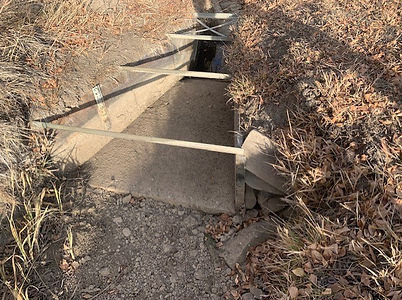
The Flume is located in the ditch running along CR 5. It is a 24" Parshall Flume which is a passive device calibrated to indicate the volume of water flowing through it.
More details on Parshall Flumes follow this link: Flume
Headgate on Dallas Creek
Caution! Adjusting the headgate can cause flooding and property damages.
Always consult with the board of directors first.

Flume on CR 5
Gauge

Gauge
How much water is running through our ditch?
Adjusting the height of the Headgate modifies the amount of flow diverted from the Dallas Creek into the Wood-Perry ditch.
CAUTION!!: Only board members should make adjustments to the Headgate as improper adjustments can casue flooding and property damage.
The vertical gauge in the Parshall flume is calibrated to indicate the water flow rate in cubic feet per second(cfs).
As a reference, one cubic foot is equal to 7.48 gallons.
When no restrictions are in place, our allocated water share is 3.62 cfs or 0.6 on the flume gauge. NOTE: this amount includes the water for upstream users outside the Dallas Meadows community.
Parshall Flume Gauge to CFS Conversion Table